
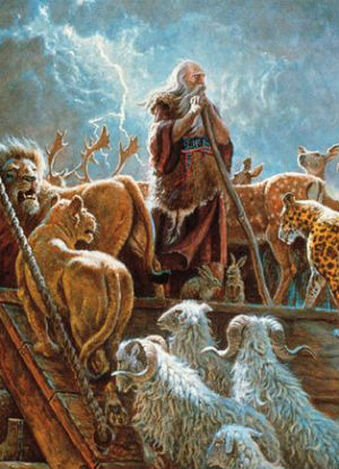
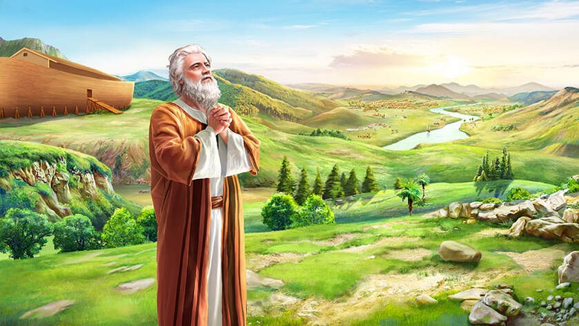
The Great Flood
Did the Great Flood actually occur and if so, what evidence is there in modern time for such a thing having taken place?
First, was this simply a big local flood or was this truly a global event?
7:19 And the waters prevailed exceedingly upon the earth; and all the high hills, that were under the whole heaven, were covered.
Genesis 7:19
Genesis 7:19

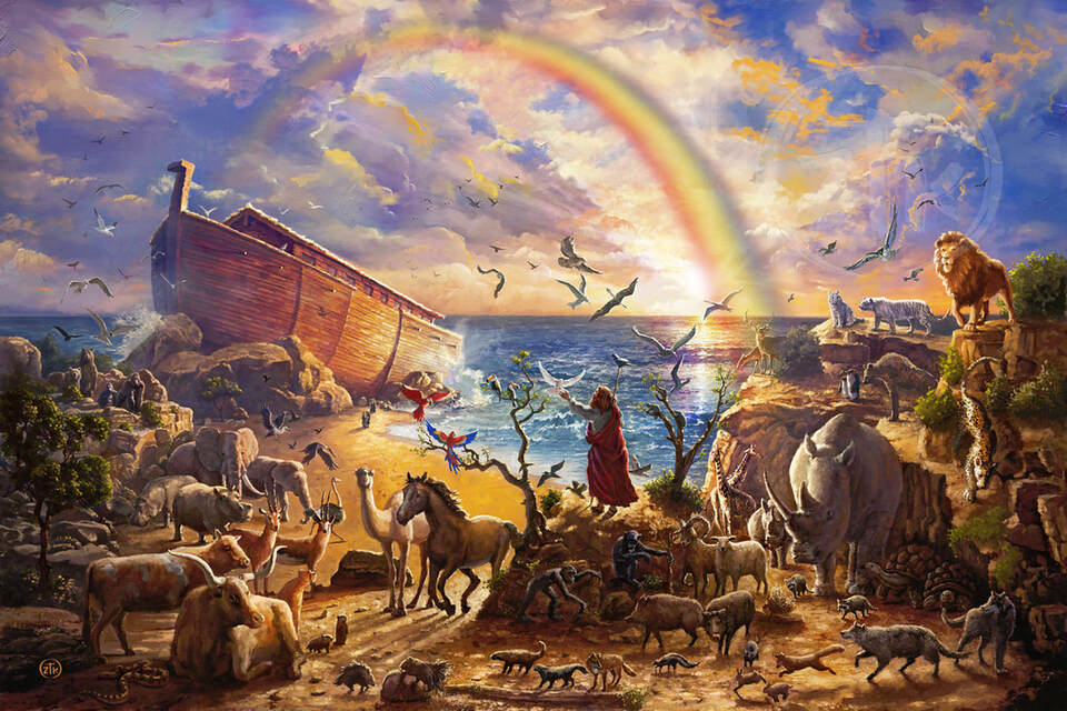
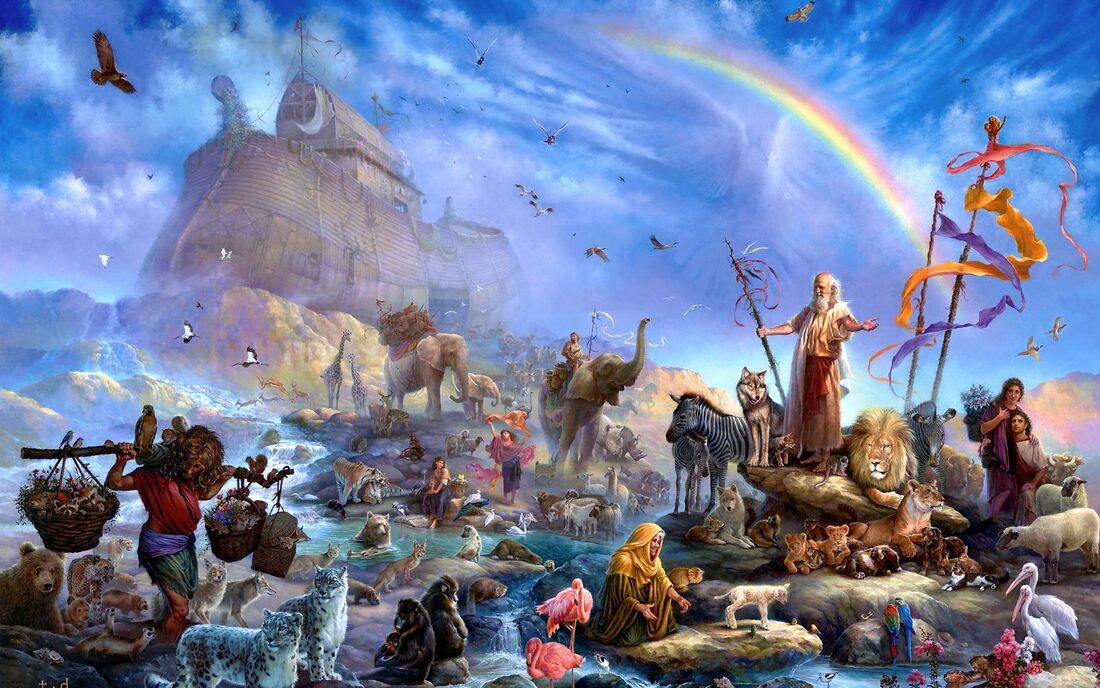
One might initially find this hard to believe, but consider flood traditions for one thing.
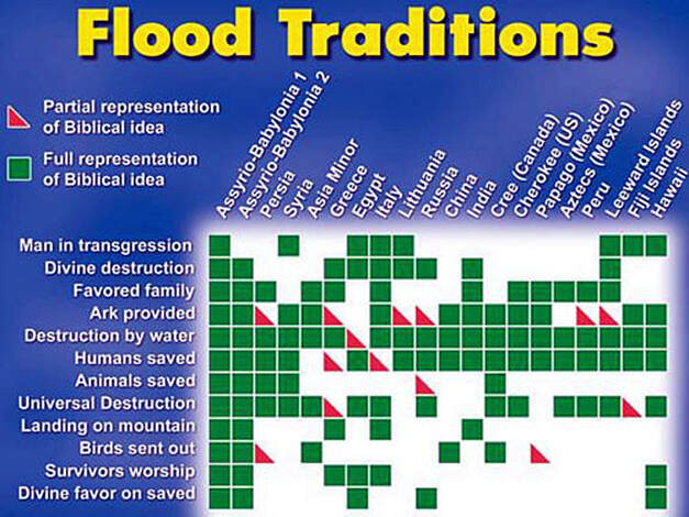

"The global flood catastrophe is one of the key facts of all history. Not only is there a mass of geological evidence,it has left an indelible impression on the memory of the entire human race. An analysis of some 600 individual flood traditions reveals a widespread concurrence on essential points: the prior corruption of mankind, a flood warning unheeded by the masses, a survival vessel, the preservation of up to eight people with representative animal life, the sending forth of a bird to determine the suitability of reemerging land, significance in the rainbow, descent from a mountain, and the re-population of the whole earth from a single group of survivors."
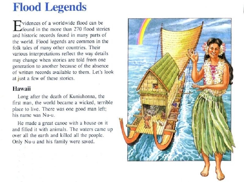
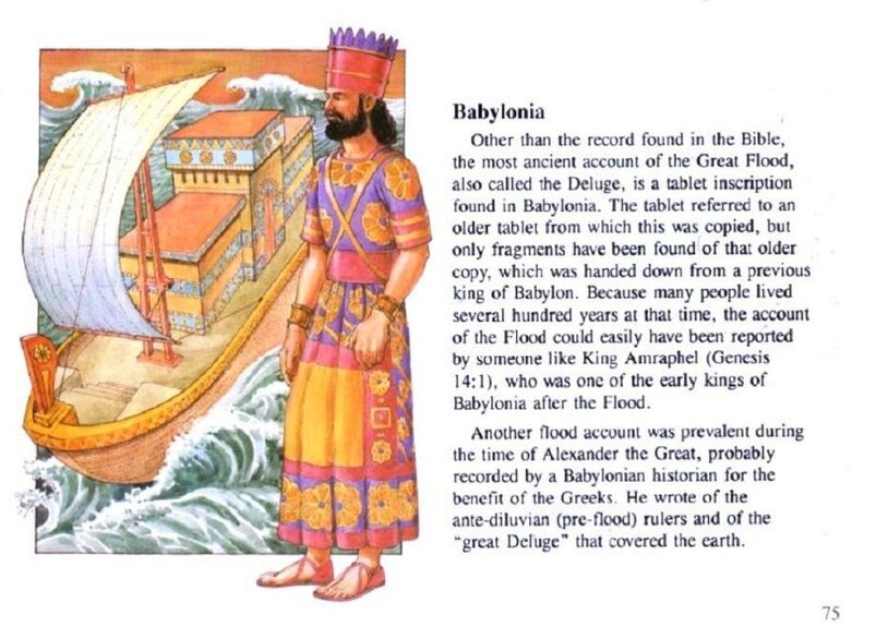

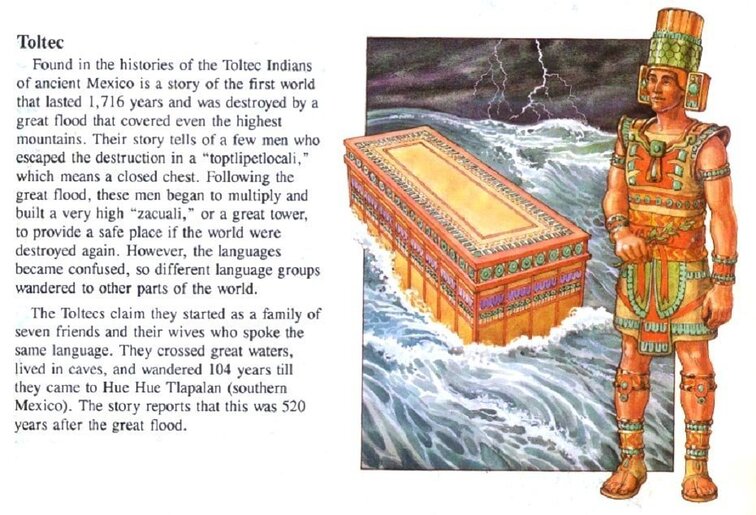


"Especially remarkable is the persistence of that biblical name Noah. And this is particularly so when you consider the ultimate language differences between peoples, and the extreme local distortions which (developed in flood legends. Yet the name survived virtually unchanged in such isolated places as Hawaii (where he was called Nu-u), the Sudan (Nuh)...the Amazon region (Noa), Phrygia (Noe) and among the Hottentots (Noh and Hiagnoh)." Think about this. Did each of these nations independently concoct the same basic name for a flood-surviving ancestor? Or did these widely separated peoples refer back to the same family of survivors?

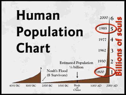
"One of the reasons that the earth cannot be billions of years old is because, to put it plainly, there aren’t enough people here. Let’s look at how the world’s population acts as a limiting factor to the age of the earth." "The latest official current world population estimate for mid-year 2010, is estimated at 6,852,472,823, or roughly seven billion people. In 1990, just 21 years ago, the earth’s population at that time was just over five billion people." "All the textbooks and population statistics indicate about 1800 there was one billion people in the world." "Well, you don’t have to be clairvoyant to quickly surmise given this trajectory, that your population does not even stretch back seven thousand years let alone the 3.4 billion years..." "Charting the population growth of the earth demonstrates that our population got started approximately 4,400 years. I bet by eight people."


Before getting deep into geology, is there any evidence for remains of Noah's Ark in the world today?
8:4 And the ark rested in the seventh month, on the seventeenth day of the month, upon the mountains of Ararat.
Genesis 8:4
Genesis 8:4
"'The name Ararat, as it appears in the Bible, is the Hebrew equivalent of ...Urartu, ancient country of southwest Asia...mentioned in Assyrian sources from the early 13th century BC' Encyclopaedia Britanica 15th ed. Some have mistakenly assumed the Bible meant the ark came to rest on Mount Ararat (Agri Dagh), but that is not the case. Mount Ararat is 17,000 feet tall, and is a post-Flood volcanic mountain that gained its height after the Flood, therefore there is no reason to assume it is a more likely candidate for the resting place of the ark, instead it is a less likely candidate. The ark came to rest in the mountains of the ancient country of Urartu, not on Mt. Ararat."
"Flavius Josephus, c. 90 AD, the famous Jewish historian stated, "Its remains are shown there by the inhabitants to this day." He quotes [this famous Chaldean], c. 290 BC, who indicated tourists would take home pieces of the ark for making good-luck charms, 'It is said there is still some part of this ship in Armenia, at the mountain of the Cordyaeans; and that some people carry off pieces of the bitumen, which they take away, and use chiefly as amulets for the averting of mischiefs.' These comments tend to indicate its location would not be in an inaccessible area. At some point, the ark was covered by a mud and lava flow which caused future generations to lose its location."
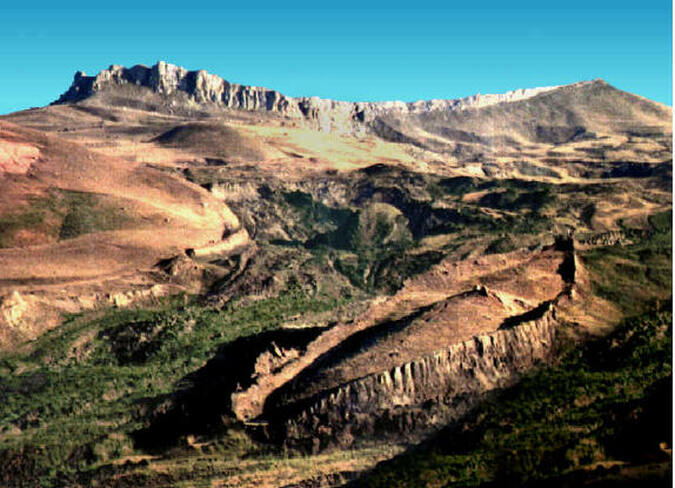
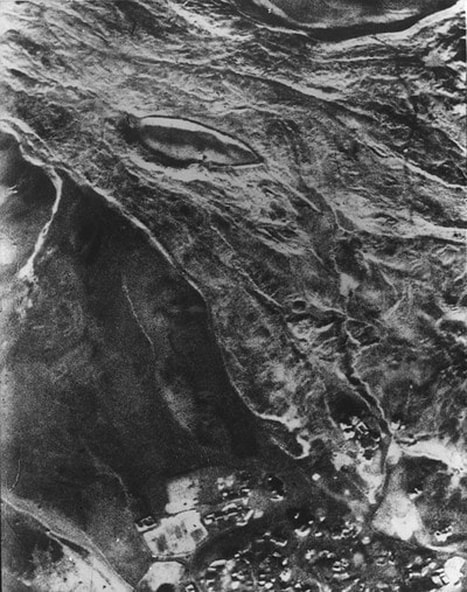
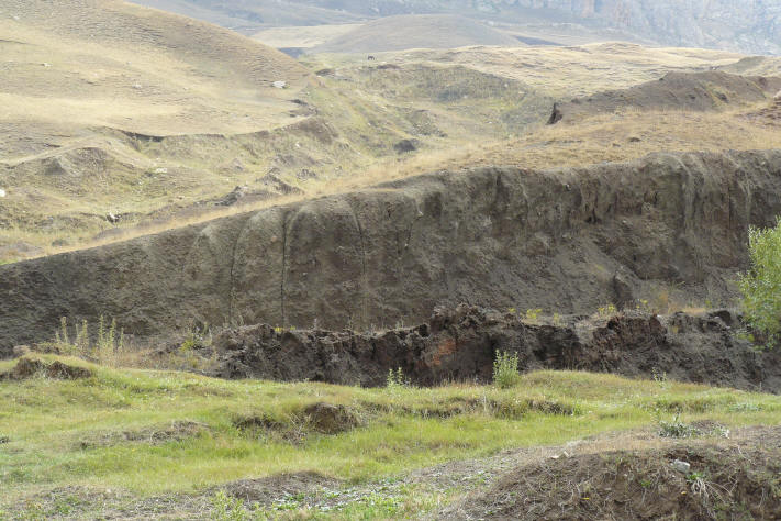
"The 1960 expedition to the ark found a formation whose top sides were even with ground level..." "The site researched by Ron Wyatt is 18.2 miles south of Mount Ararat at the elevation of 6,524 ft., in the 'mountains of Ararat.' A Turkish captain, Llhan Durupinar, was reviewing NATO Geodetic Survey photographs of the area in 1959, and noticed a boat shaped formation. Others in the U.S. then analyzed the photograph including Dr. Arthur J. Brandenberger, world famous expert in photogrammetry, who said 'I have no doubt at all that this object is a ship. In my entire career I have never seen an object like this on a stereo photo. Even the approximate length of the object fits' The Ark File, p118. An expedition sponsored by a party from the U.S. included among others, Rene Noorbergen, later author of The Ark File; and George Vandeman, evangelist, and Dr. Brandenberger. They made a visual inspection of the site and conducted no scientific studies, only some digging and dynamiting of the ark and...mistakenly concluded this site was just an 'odd geological formation.' The expedition was expecting to find on the surface of the ark 'petrified beams' The Ark File, p126, by digging in a few places. An article then appeared in the September 5th, 1960, Life magazine, shown above, revealing a very impressive aerial photo of an extremely large boat-shaped object, plus two photos taken by the expedition. Seventeen years later in 1977, Mr. Wyatt made his first of 24 trips to the ark, and he was impressed that this really was the remains of Noah's Ark! In the research he performed over the next 15 years, Mr. Wyatt successfully performed metal detection tests and subsurface radar scans of the site, and he proved this site really IS the mud-and-lava covered remains of Noah's Ark!"
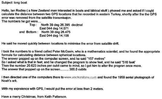
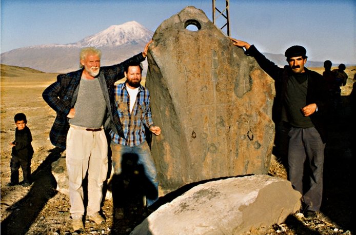
Ron Wyatt in 1977 wanted to visit the area to find the ark, but none of the 1960 group could tell him where it was located, just some where near Mt. Ararat. Ron had three days in the area, so he and his two sons prayed that the Lord would help them. They hired a taxi and started driving around, then the taxi stalled. They were surprised, and quickly piled up stones to mark the spot. The car then started and they drove off. This happened three times. The next day Ron went back to the piles of stones and walked out from them. He found the ark, the anchor stones that you will see, and the remains of Noah's house.
"The ark originally came to rest higher on the mountain after the Flood. At some point in the first two thousand years of resting in the mountains of Ararat, a volcano erupted above the ark and moved the ark further down the mountain and then impaled it on a rock outcropping where it rests today." "The ark rests on Cesnakidag Mountain, which is interpreted as 'Doomsday' Mountain. The Flood would be considered a real "doomsday" since it destroyed the world. The mountain is made of sedimentary cretaceous water laid rock, which means it was formed by the Flood waters and is not a post Flood formation."
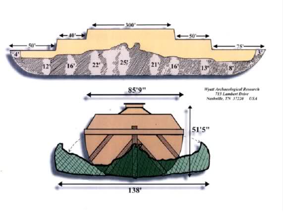
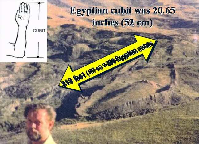
"The length of the ruins of the ark is 515 ft., which is exactly 300 Egyptian cubits (20.6 inches)! Moses was schooled in Egypt and was not familiar with the Hebrew cubit which was not even in existence when Moses wrote Genesis. So the Egyptian cubit was used by Moses when describing the measurements of the ark."
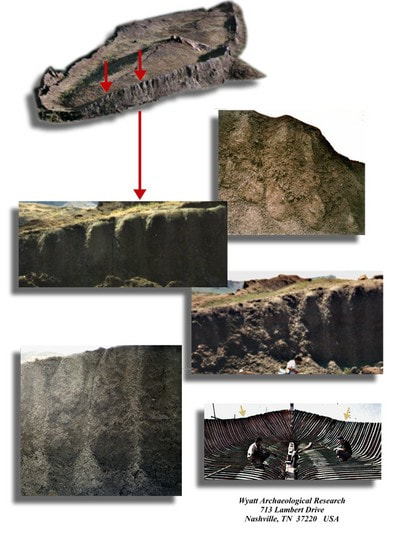
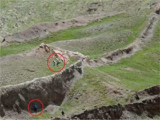
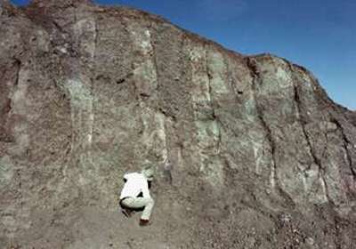
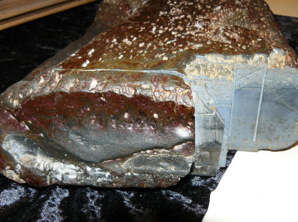
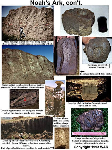
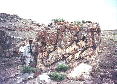
The port or eastern side of the ark, near the front, was scraped off by Ron in an effort to view the timbers without loose, crumbling material in the way. This process revealed the lighter color rib timbers in a systematic, vertical pattern. You can see a darker, curved pattern across the top, which represents the remnants of a large keelson.
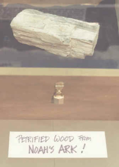
"A close-up photo of an 18 inch deck plank unearthed before Turkish officials by Ron Wyatt and features three distinct layers of wood with glue protruding from the end. It was tested and proved to be petrified wood. It is 18 inches in length and has a few visible nails. It is made of three layers of wood with dark pitch on top. At the bottom right you can see dark spots which may be consistent with Pecky Cypress wood, so this may be the gopher wood described in the biblical account. This deck timber was analyzed at Galbraith Labs in Knoxville, Tennessee, and was found to have a total carbon content of 0.7100%. From this figure you would deduct the inorganic carbon of 0.0081%, leaving 0.7019% organic carbon, which is a much higher level of organic carbon than inorganic, so this indicates this was once living matter."
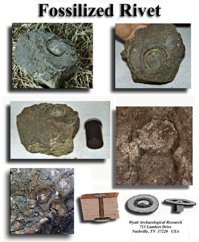
"Ron Wyatt found a beautiful specimen of one of the metal rivets used on the ark. It was tested and found to contain high-tech metal alloys, such as titanium, magnesium, and aluminum, etc. Critics have said Ron did not find this fine specimen on the ark but just manufactured it. Well...we found the same objects and had them tested. They too proved to have the same metals, in the same percentages!"
"The Turkish government has double-verified...Wyatt's tests, and they have given him credit for the discovery. The announcement appeared in Turkey's largest newspaper on [6/21/1987]. The area was first designated a National Park, and then it was upgraded to the status of a National Treasure."
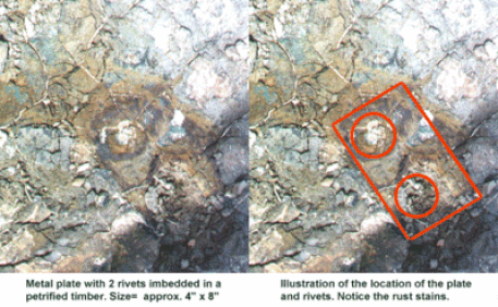
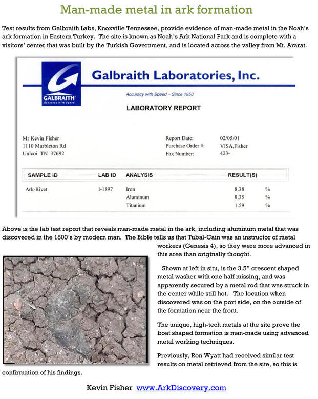
"Galbraith Laboratories of Knoxville Tennessee has tested the specimen for three metals I requested. I asked them to test for aluminum metal, iron metal, and titanium metal. It costs $60 to test for each metal requested. The results show 8.35 % iron metal, 8.35% aluminum metal, and 1.59% titanium metal. ALUMINUM AND TITANIUM METALS ARE NOT FOUND IN NATURE!!! THIS OBJECT IS MAN-MADE, USING ADVANCED TECHNOLOGY!! These results are similar to those produced in the analysis of the rivet found by Mr. Wyatt. Since the specimen is fossilized, it is assumed a large portion of it is now silica replacement, reducing the percentage of metal that was originally in it when it was made. These rivets are found in several locations on the outside of the Ark, and are probably buried inside the Ark by the hundreds or thousands. In comparison to others, this specimen is in poor condition."
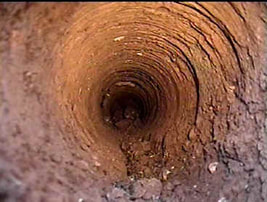
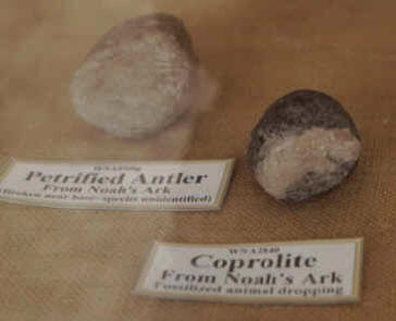
"This is a look through the six inch diameter core drill Ron Wyatt performed years ago. It leads to a chamber which contained petrified animal dung coprolite (below), cat hair, the base of an antler (below), human hair, and man-made fiber that is similar to fiber optic."
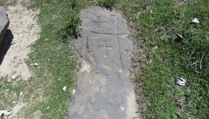
Could this be the actual altar that Noah used to make postflood sacrifices if it's found fairly close by in a natural amphitheater?:
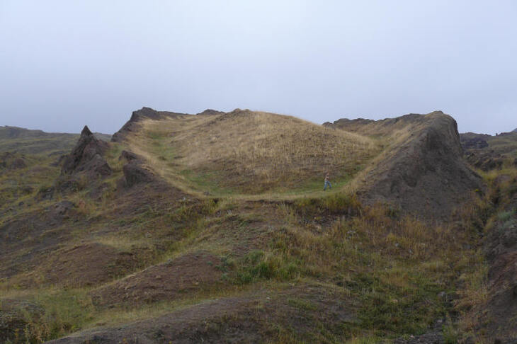
About 15 miles from the ark is the village of Arzep, formerly known as the Village of Eight, where the sea anchor stones were cut off the ark and landed underwater in this area.

"The region around the ark has a rich history of evidence identifying this area as the correct landing place for the ark." "The valley below the ark is interpreted as The Valley of Eight." "The name for the mountain where the ark rests is interpreted as Doomsday mountain." "The village where the majority of the anchor stones are found is called Arzep or The Place of Eight."
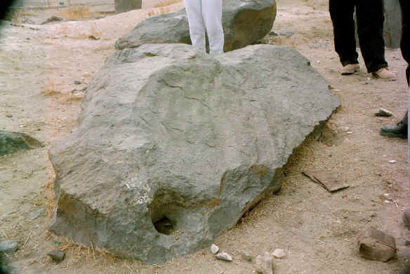
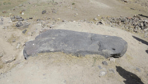
"The anchor stones were cut from the ark as the waters were starting to recede." "See Wikipedia and search for 'sea anchors' to learn more about how they can keep a ship facing oncoming waves when the stones were attached to the front of the ship."
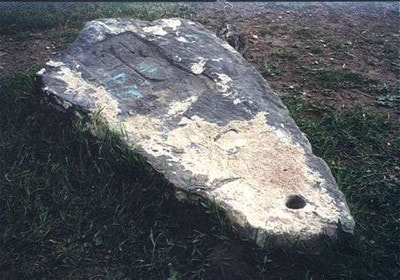
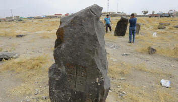
Below: "This stone is out in the countryside and does not have crosses. Perhaps it was uncovered at a later date."
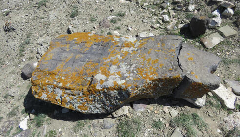
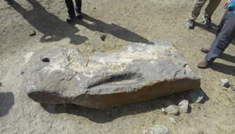
Others out in the country side below.
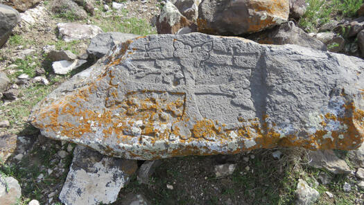
A stone with possible a image of the tower of Babel here:
So is the true Ark of Noah actually revealed above?
"It is in the shape of a boat, with a pointed bow and rounded stern."
"Exact length as noted in biblical description, 515 feet or 300 Egyptian cubits. (Egyptian not Hebrew cubit would have been known to Moses who studied in Egypt then wrote Genesis.)"
"It rests on a mountain in Eastern Turkey, matching the biblical account, 'The ark rested . . . upon the mountains of Ararat' Genesis 8:4. (Ararat being the name of the ancient country Urartu which covered this region.)"
"Contains petrified wood, as proven by lab analysis."
"Contains high-tech metal alloy fittings, as proven by separate lab analyses paid for by Ron Wyatt, then performed later by Kevin Fisher of this web site. Aluminum metal and titanium metal was found in the fittings which are MAN-MADE metals!"
"Vertical rib timbers on its sides, comprising the skeletal superstructure of a boat. Regular patterns of horizontal and vertical deck support beams are also seen on the deck of the ark."
"Occupied ancient village at the ark site at 6,500 ft. elevation matching Flavius Josephus' statement 'Its remains are shown there by the inhabitants to this day.'"
"Dr. Bill Shea, archaeologist found an ancient pottery sherd within 20 yards of the ark which has a carving on it that depicts a bird, a fish, and a man with a hammer wearing a headdress that has the name 'Noah' on it. In ancient times these items were created by the locals in the village to sell to visitors of the ark. The ark was a tourist attraction in ancient times and today."
"Recognized by Turkish Government as Noah's Ark National Park and a National Treasure. Official notice of its discovery appeared in the largest Turkish newspaper in 1987."
"Visitors' center built by the government to accommodate tourists further confirms the importance of the site."
"Huge anchor stones were found near the ark and in the village Arzap, 15 miles away, which hung off the rear of the ark to steady its ride. The ark rests upon Cesnakidag (or Cudi Dagi) Mountain, which is translated as 'Doomsday' Mountain."
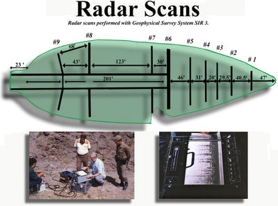
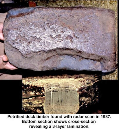
"Radar scans show a regular pattern of timbers inside the ark formation, revealing keels, keelsons, gunnels, bulkheads, animal chambers, ramp system, door in right front, two large barrels in the front 14' x 24', and an open center area for air flow to all three levels."
"New, 2016, high resolution, resistivity scans were done on the ark and reveal the same man-made elements that Ron Wyatt found in his 1985 scans. See www.noahsarkscans.nz"
"It is in the shape of a boat, with a pointed bow and rounded stern."
"Exact length as noted in biblical description, 515 feet or 300 Egyptian cubits. (Egyptian not Hebrew cubit would have been known to Moses who studied in Egypt then wrote Genesis.)"
"It rests on a mountain in Eastern Turkey, matching the biblical account, 'The ark rested . . . upon the mountains of Ararat' Genesis 8:4. (Ararat being the name of the ancient country Urartu which covered this region.)"
"Contains petrified wood, as proven by lab analysis."
"Contains high-tech metal alloy fittings, as proven by separate lab analyses paid for by Ron Wyatt, then performed later by Kevin Fisher of this web site. Aluminum metal and titanium metal was found in the fittings which are MAN-MADE metals!"
"Vertical rib timbers on its sides, comprising the skeletal superstructure of a boat. Regular patterns of horizontal and vertical deck support beams are also seen on the deck of the ark."
"Occupied ancient village at the ark site at 6,500 ft. elevation matching Flavius Josephus' statement 'Its remains are shown there by the inhabitants to this day.'"
"Dr. Bill Shea, archaeologist found an ancient pottery sherd within 20 yards of the ark which has a carving on it that depicts a bird, a fish, and a man with a hammer wearing a headdress that has the name 'Noah' on it. In ancient times these items were created by the locals in the village to sell to visitors of the ark. The ark was a tourist attraction in ancient times and today."
"Recognized by Turkish Government as Noah's Ark National Park and a National Treasure. Official notice of its discovery appeared in the largest Turkish newspaper in 1987."
"Visitors' center built by the government to accommodate tourists further confirms the importance of the site."
"Huge anchor stones were found near the ark and in the village Arzap, 15 miles away, which hung off the rear of the ark to steady its ride. The ark rests upon Cesnakidag (or Cudi Dagi) Mountain, which is translated as 'Doomsday' Mountain."
"Radar scans show a regular pattern of timbers inside the ark formation, revealing keels, keelsons, gunnels, bulkheads, animal chambers, ramp system, door in right front, two large barrels in the front 14' x 24', and an open center area for air flow to all three levels."
"New, 2016, high resolution, resistivity scans were done on the ark and reveal the same man-made elements that Ron Wyatt found in his 1985 scans. See www.noahsarkscans.nz"
"An excavation permit to dig into the ark has never been issued by the Turkish government, preventing thorough documentation of the site. Partial documentation of this site has periodically appeared on The 700 Club, 20/20, The Discovery Channel, The Learning Channel, CNN, Encounters, and various local Christian TV stations, but Ron Wyatt never had his own documentary shown on national television. An excavation would uncover petrified timbers inside, so we are hopeful a dig can someday take place."


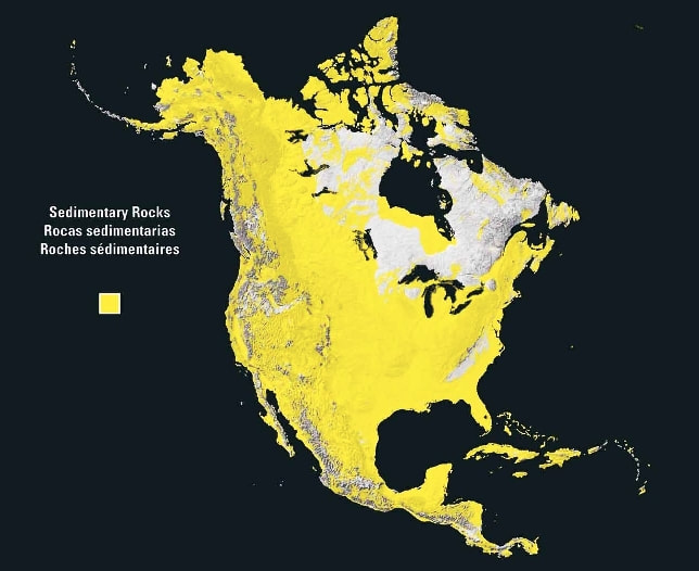
Next we come to flood geology and I suppose that sedimentary rock in general is a nice place to start. How telling if sedimentary rock in and of itself is a type of rock that's formed by sedimentation of material at the Earth's surface and within bodies of water?
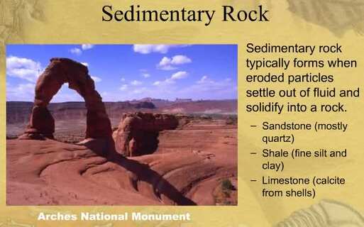
What should it tell us if sedimentary rock is a type of rock that's formed by sedimentation of material at the Earth's surface and within bodies of water and yet it's widespread across the world and it's almost always a thin veneer over a crust consisting mainly of igneous and metamorphic rocks?
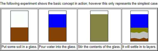
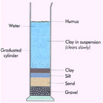
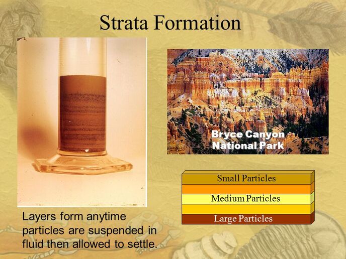
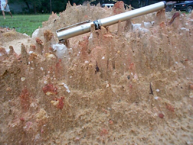
"If we take soil, sand, gravel, etc, and put them into a container, fill the container with water, shake them all up, and [sit] the container on the ground, after a short time sitting, the sediments will begin to settle into layers automatically based on their density in water. This is a repeatable experiment that demonstrates the forming of layered sediments, and if there was a global flood in this world, we should see layers of sediments all over the world, and indeed, that's what we find."

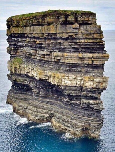
Compare this last image with the following if we have an image of a geologic formation off the coast of Ireland and people are pushed to believe that this shows vast epochs of time upwards of hundreds of thousands or millions of years. Do you think these layers would sit this smoothly without erosion around the coast of what is now Ireland for even a decade let alone that long?
Also, liquefaction is the process that solid sediments transform into a substance that acts like a liquid. An example is of this is quicksand, beach sand and mudslides. After the Flood the earth would have theoretically have continued to quake and shift. The strata layers continued to shift and move from the beginning of the flood until years long after. This would be yet another process that developed the shifting Geologic Columns and the fossils within them as we find today.
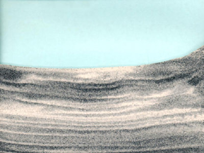
How about we really think about this and ask ourselves if we were lied to if we are repeatedly told that layers like what are found in Bryce Canyon represented vast geologic timespans?
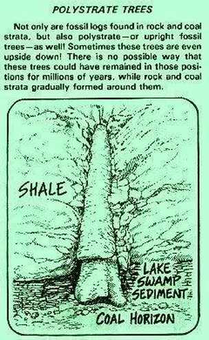
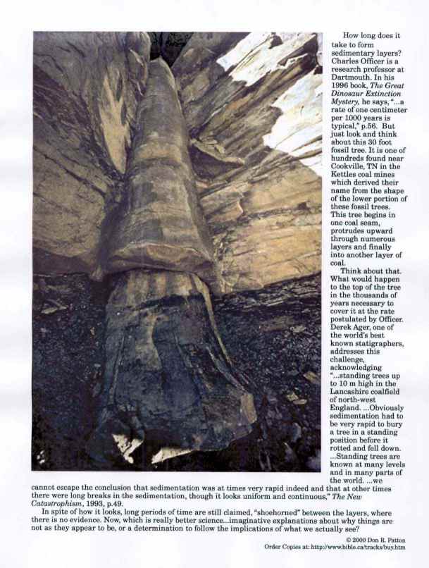
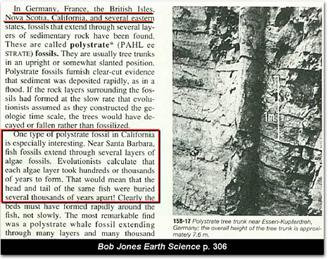
Consider polystrate fossils as well if they should help hammer a point home and put an exclamation point on things said above.
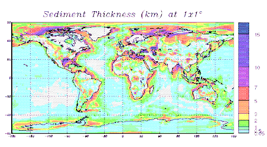
Also consider moist sediment in and of itself that has not dried out to become sedimentary rock. If there was a global flood that resulted in sediment filled water across the world and then things began to drain, where would you expect the most sediment to end up flowing into? Gulfs? Consider below and then also consider how much purple is in the northern hemisphere as opposed to the south as we move into discussion regarding where Flood waters came from.
If there was a Global Flood, where did the Flood water come from and where did it go and what does it have to do with the geology that we see across the world?
7:11 In the six hundredth year of Noah's life, in the second month, the seventeenth day of the month, the same day were all the fountains of the great deep broken up, and the windows of heaven were opened.
Genesis 7:11
Genesis 7:11
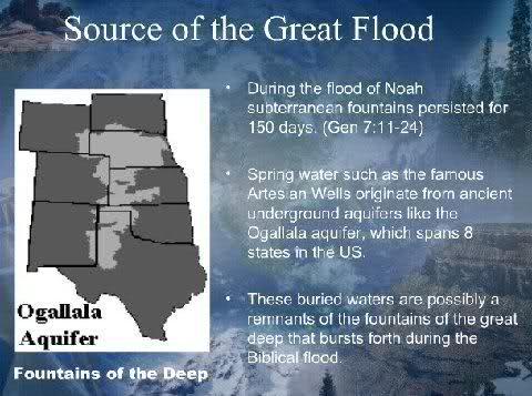
Where would the actual fountains of the great deep be though? Is there any sign near a giant underground body of water like the Ogallala Aquifer that could give us a hint in regards to where?
"Yellowstone National Park has more than 80% of the world's known geysers."
"The research team surveyed the volcanically active Yellowstone region, home to 80 percent of the world's geysers and half of its geothermal features."
"The research team surveyed the volcanically active Yellowstone region, home to 80 percent of the world's geysers and half of its geothermal features."
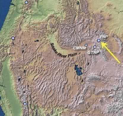
Hmm. How interesting if secular academia itself informs us that the vast vast majority of the world's geysers and about half of it's total geothermal features exist within Yellowstone Nation Park. And better yet? There's a huge spillway for massive water flow that stems from Yellowstone as well?
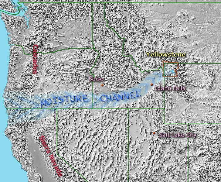
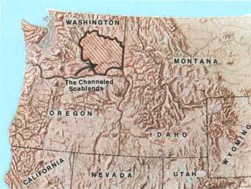
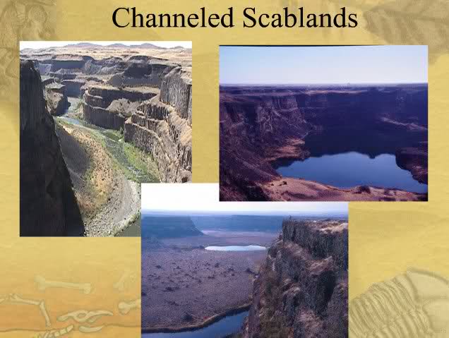
Now consider where Snake River Plain takes us if we follow it from Yellowstone. "National Geographic is running a good story by Glen Hodges on the mysterious geology of the Columbia Plateau in eastern Washington state. In the midst of this desert are what look like the remnants of great floods: huge gravel bars, mighty erosion channels, things that look like the potholes that form in the bottom of rivers but are ten times the size. A feature known as Dry Falls looks for all the world like a gigantic waterfall, ten times the size of Niagra, except that there is no river anywhere in sight. Geologists call the region the Channeled Scablands."
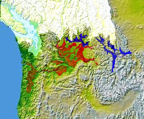
"In 1909, the Seattle teacher [Harley Bretz] visited the University of Washington to see the U.S. Geological Survey’s new topographic map of the Quincy Basin, a large area on the west side of the Columbia Plateau. He was 27, with no formal training in geology, but when he looked at the map, he noticed a striking feature: a huge cataract (much like Dry Falls) on the western edge of the basin, a place where water appeared to spill out of the basin and into the Columbia River, gouging a canyon several hundred feet deep. The falls would have been bigger than Niagara, but there was no apparent source of water for them—no signs whatsoever of a river leading to the cataract." "Bretz asked faculty in the department about the feature, called Potholes Coulee, but they had no answers for him. Nor could they explain many of the other unusual features of the region. That’s when, as legend has it, Bretz decided to become a geologist."
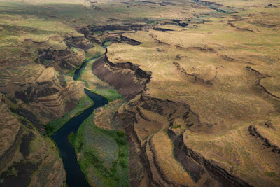
Bretz realized that this landscape must have been created by gigantic floods. But when he tried to convince other geologists, nobody believed him. Geology was in the grip of an orthodoxy called Uniformitarianism, which held that the earth has always been shaped by the everyday forces we can see around us. Bretz's giant floods sounded to rigorous scientists like something from the Bible-based science of the 1700s, and they refused to believe him.
Now consider the western United States in general. A great land of exposed sedimentary rock? And what's sedimentary rock if not a type of rock that's formed by sedimentation of material at the Earth's surface and within bodies of water?
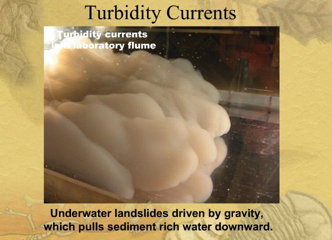
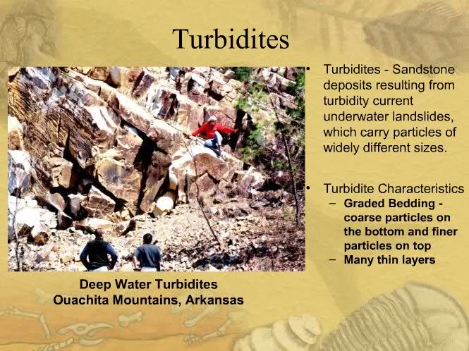
I propose that there was a global flood that involved widespread turbidity currents and these turbidity currents led to widespread turbidites focused and spiraling out from around the Yellowstone area specifically.
Now what would have caused the Yellowstone area to have been broken up in the first place? Is there any sign of massive geologic trauma nearby? Well consider what we find toward the south and just down the road from the Grand Canyon.
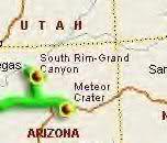
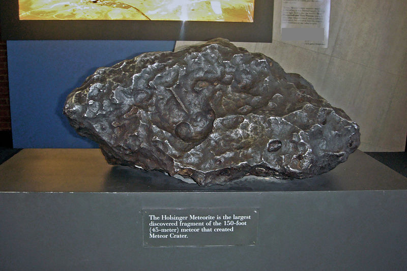
How amazing and also suspicious if there is a massive crater that is not only huge but seem to have four sides as if something with a four sided base struck the world and caused it?
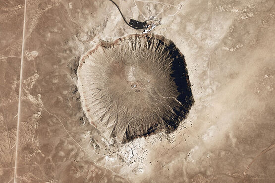
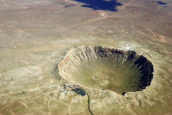
And not only that but the largest remaining fragment has a silver color as if some kind of metallic object caused it?
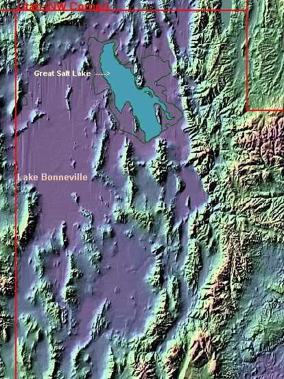
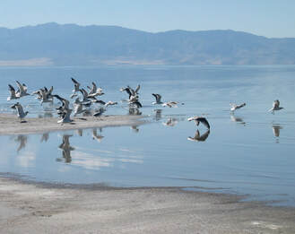
Is there any other evidence in the western United States that a global cataclysmic flood began around there though? Well consider the Great Salt Lake if it's essentially a salt water sea that's stuck between mountains and it's even complete with sea gulls.
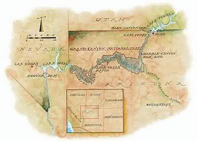
Now consider what we find just upstream of Grand Canyon. What do we have if not evidence for two giant lakes similar to Great Salt Lake that actually did find a way out to the ocean sometime after the Flood? Two giant lakes that ended up breaching one or more natural dam and forming one of the most beautiful pieces of scenery in the world as a result? Remember this red circle or what I call lynch pin as we discuss the Marble Canyon later on below.
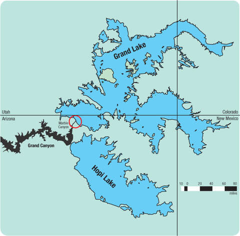
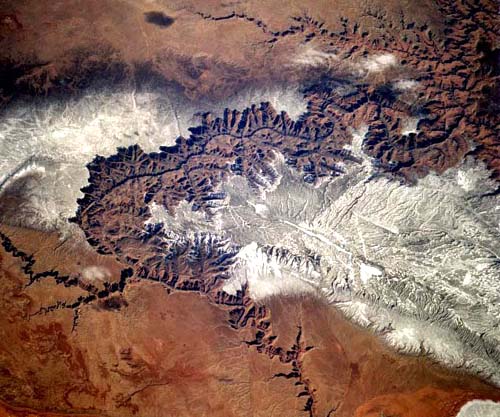
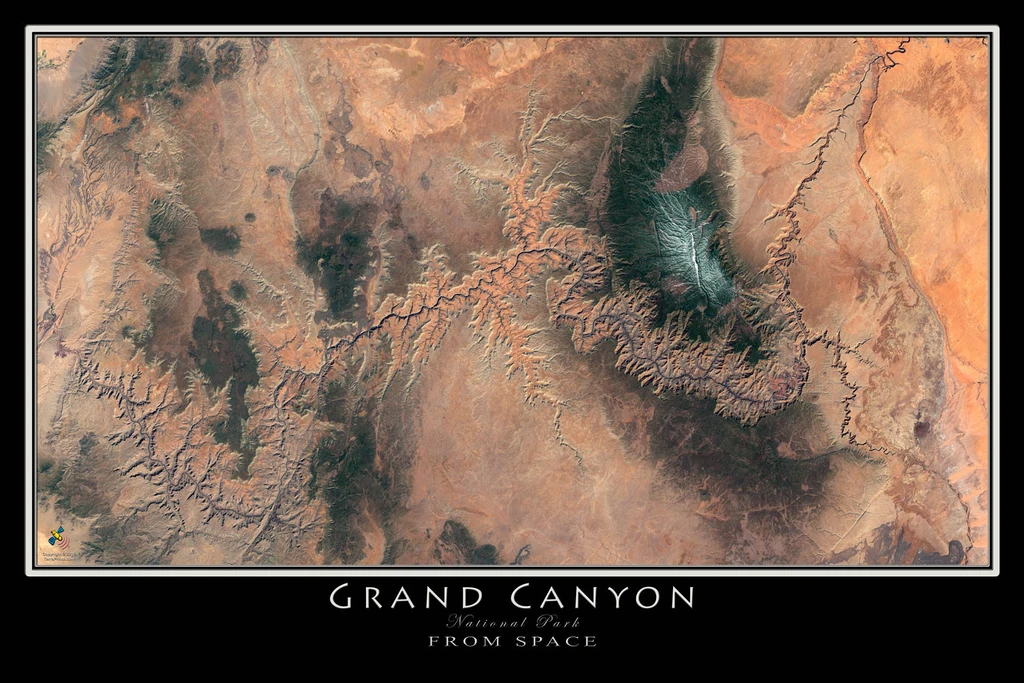
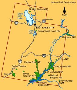
Before we take a deep dive into the Marble Canyon and the Grand Canyon, consider how many curious features exist in areas marked as Grand Lake and Hopi Lake below. How fascinating if Monument Valley and Rainbow Bridge and Petrified Forest National Park and many other peculiar geological features are all located in areas that were once basins of bodies of water just east and northeast of the Grand Canyon? I suggest you note this map below for later use as I refer back to it a number of times. I will call it MAP X moving forward:
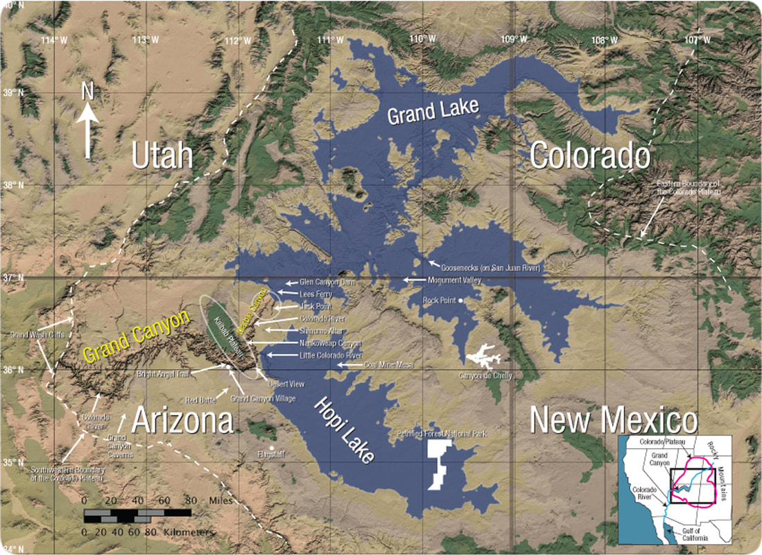
Now let's focus on Marble Canyon and the Grand Canyon itself for a moment before circling back around to other locations referenced on MAP X.
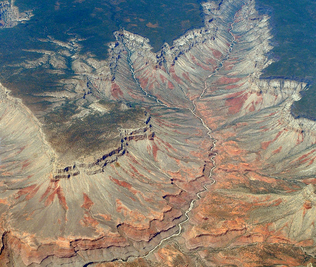
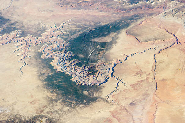
Is the Grand Canyon the product of a little river and a lot of time or a massive onslaught of water and a relatively short period of time? Notice how wide this canyon is below and notice the lines of sedimentation in the sides of the canyon. Is it logical to believe that layers slowly built up over millions of years and this left smooth layers representing vast geologic times without any erosion between the layers?
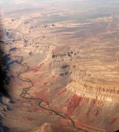
Furthermore, I suggest you consider this below and ask yourself a question. If the Colorado River enters the Grand Canyon around 2,800 feet above sea level and yet the Grand Canyon has a highest elevation point of around 6,900 feet, when does water flow uphill? See a snowline below to help put things in perspective?
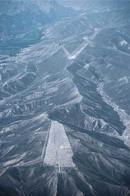
Now look back to MAP X and see a separate canyon just upstream from the Grand Canyon called Marble Canyon? Hmm. How peculiar if we have a main funneled canyon and we also have a smaller canyon that's essentially a crack in solidified mud containing the Colorado River besides? Where did Each canyon come from in that case?
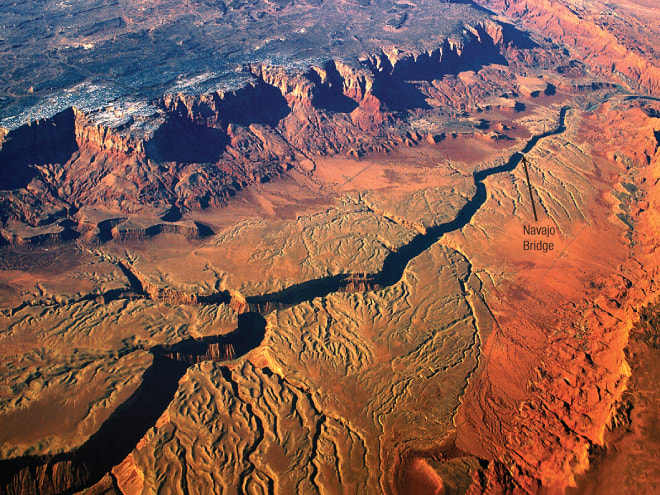
What do we have here if not a gigantic funnel canyon that is the result of Grand Lake spilling over a natural dam if you consider it's location on MAP X and consider how aligned Vermillion Cliffs are with Echo Cliffs? Notice also the yellow arrows or the barbed canyons. Canyons that go against the flow of the Colorado River.
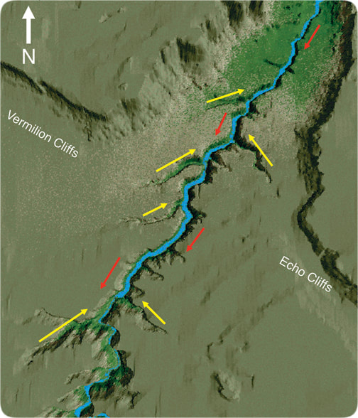
"With all this weight removed from northern Arizona, the rock layers below rose, tipping layers under the funnel and elsewhere down a degree or so to the north." "Thus the subsurface flow (and the 'sink valleys' above) began flowing toward the north." "Water flowing out of the funnel walls---Vermilion Cliffs on the west and Echo Cliffs on the east---flowed into and deepened the north flowing 'sink valleys,' giving them shape of the barbs in barbed wire." "Tributaries almost always enter rivers at acute angles." "However, the barbed canyons are oriented at obtuse angles to the Colorado River; they are 'backward.'" "Some barbed canyons are huge----a mile wide and 1,700 feet deep where they enter Marble Canyon."
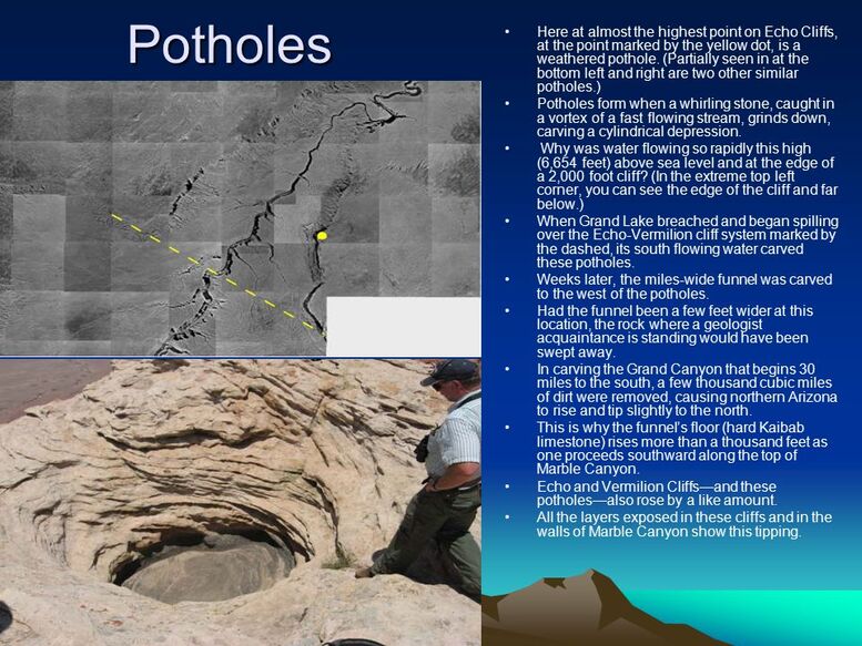
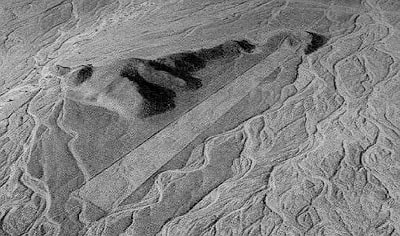
56Now consider this image below and try to imagine what would happen if Grand Lake breached it's rim and carved Marble Canyon into the cliffs on the top right. Soon the water barrels in and yet is trapped by the (shown as green?) Kiabab Uplift and then rushes toward the bottom where it meets the edge of Hopi Lake and combines with water from it to breach the Kiabab Uplift itself and give us the Grand Canyon?
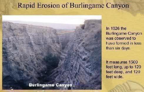
Now compare the Grand Canyon with Burlingame Canyon and consider how many smooth sedimentary layers are revealed in each and ask yourself if either really took more than a week to form.
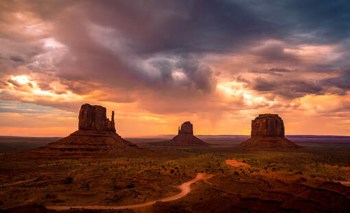
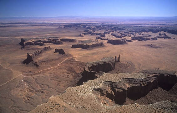
Now let's consider what remains in the areas that were once the bottom of Grand Lake and Hopi Lake according to MAP X and let's start with Monument Valley. Note the location is the map above and consider what we find here:
Can you believe that all of this was carved out by meandering rivers if that is what secular academia wants you to believe? Imagine thinking that every little gap here between the buttes was just carved out at one point or another in history by a slow meandering river even if there is no other place in the world quite like it.
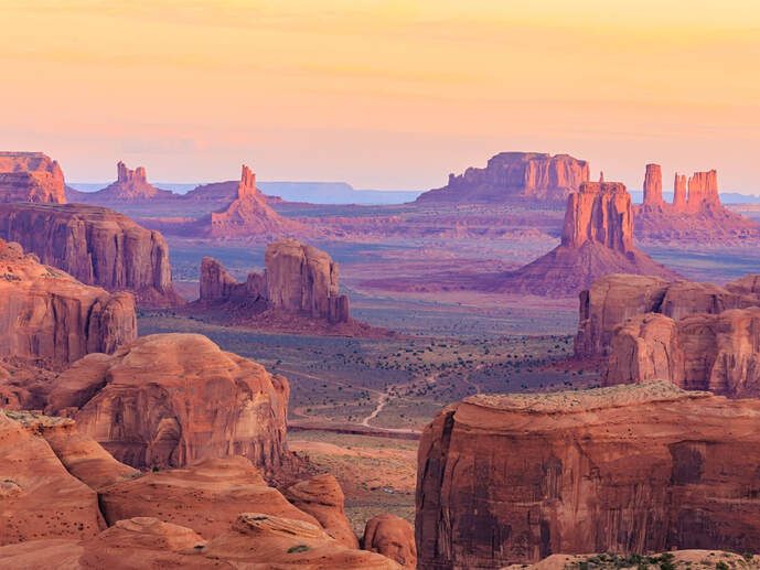
I propose an alternate theory that the buttes are the remains of a thick and muddy lake bed that was quickly laid out during the flood and that it began to solidify in some places more than others before a natural dam collapsed toward the southwest. And I propose that most of the muddy lake bottom quickly rushed out at that point leaving behind a more solid siltstone valley floor that was much closer to the original preflood level.
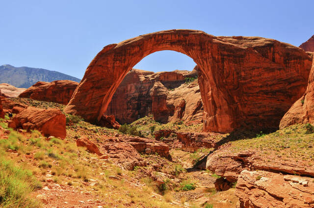
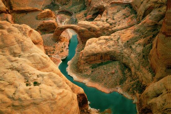
Now consider Rainbow Bridge and notice how much of a bottle neck it rests in if it's found just north of the word Canyon in "Glen Canyon Dam" on the most previous map that I told you to note above.
What is this the result of if not muddy water rushing through a muddy bottleneck and leaving amazing pieces of geologic artwork in it's wake with muddy sediment eventually becoming sedimentary rock over following centuries?:
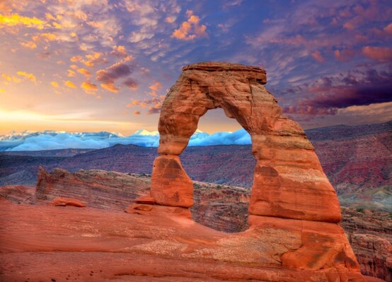
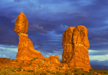
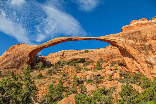
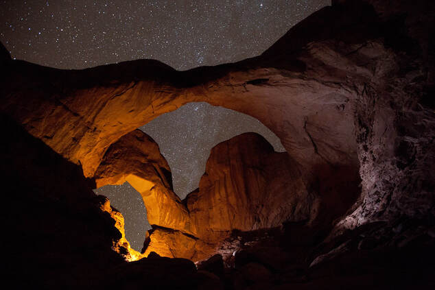
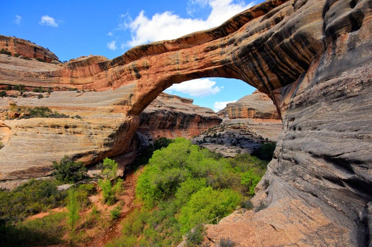
If you want to see even more evidence for an early postflood playground of mud resulting from early postflood lakes similar to Great Salt Lake breaching a natural dam and leaving a jungle gym of exposed sedimentary geology behind, consider Arches National Park, Canyonlands National Park, Natural Bridges National Monument, Glen Canyon National Recreation Area or consider some images below.
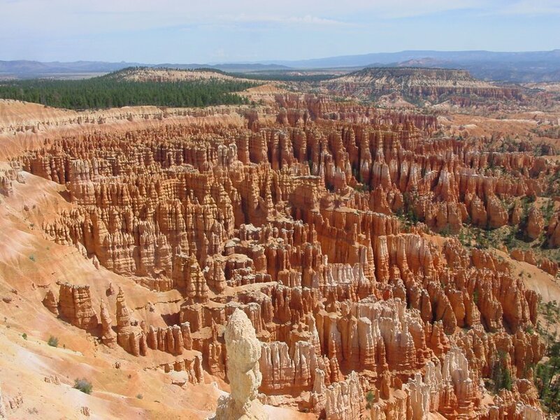
But is there anyway this could have formed without millions of years of erosion if this is Bryce Canyon and found just to the north of the Grand Canyon as well?:
How about compare with this:
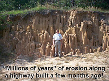
And ask yourself how long you think it took this to form:
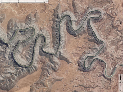
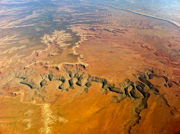
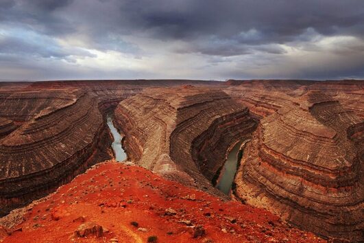
Let up also consider the Goosenecks location in MAP X and ask yourself what would happen if a massive lake quickly emptied and there was a wide expanse of muddy lake bed left behind? What would you expect to happen if a slow meandering river then found it's way into the mud and slowly rolled over the muddy lake bottom for several millennia?
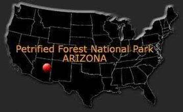
Notice also the location of the Petrified Forest National Park on MAP X. What happened here if we have a 230 square mile (600 square kilometer) park that's filled with large deposits of petrified trees and why would we not find this in many more locations around the world?
I propose that there was an ancient forest around this area that was essentially buried in muddy sediment during the Flood and that much of this had began to fossilize before a natural dam broke forth to the west and left the area a mostly washed out and drained out petrified wasteland.
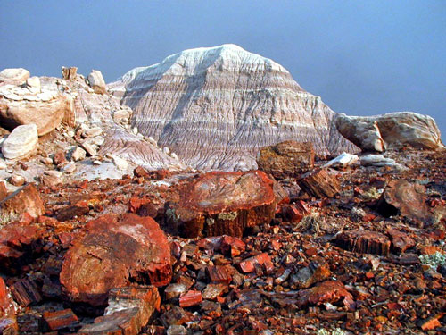
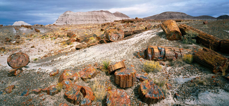
What else would explain it if you consider what's said on the image below and think about how fast logs normally begin to break down and decompose when left to exposed air above ground?
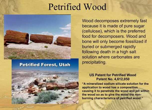
"Other organic matter—typically leaves, seeds, pine-cones, pollen grains, spores, small stems, and fish, insect, and animal remains—have been preserved in the park as compression fossils, flattened by the weight of the sediments above until only a thin film remains in the rock." "While Petrified Forest contains abundant and colorful fossil plant deposits, much of the what has made the park's paleontology resources famous worldwide is its myriad fossilized reptiles, some of which still have living descendants!"
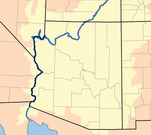
So are we sure the Grand Canyon was not actually carved into an already existing Kiabab Uplift as a result of the Flood and two natural dams on top of the Colorado Plateau being breached? Getting back to MAP X, notice the dashed line border of the Colorado Plateau and the Grand Canyon essentially coming to an end at the edge of it. Follow the Colorado River from there and it takes you towards the Gulf of California and a huge swath of terrain known as the Sonoran Desert.
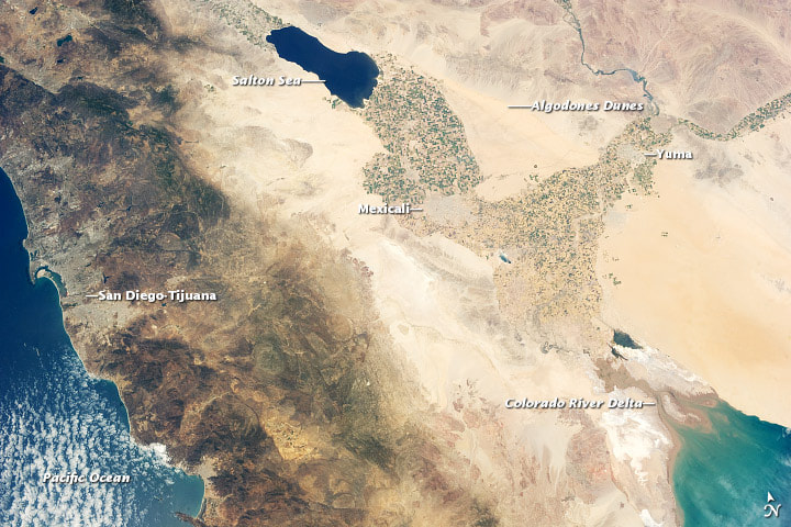
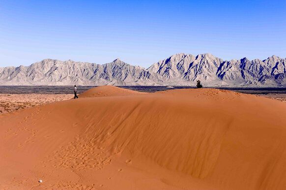
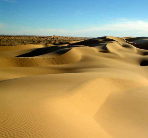
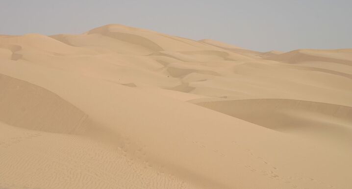
This desert contains large sand dunes with some examples shown below. Just look at this and then think about what would happen if the Great Salt Lake was quickly washed out toward the ocean. Consider how much sand would be left behind in it's wake.
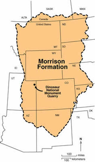
Now consider the Morrison Formation as well. Is it a coincidence if much of the features we have been discussing is part of a distinctive sequence of sedimentary rock which has been the most fertile source of dinosaur fossils in North America and it's centered around Yellowstone?
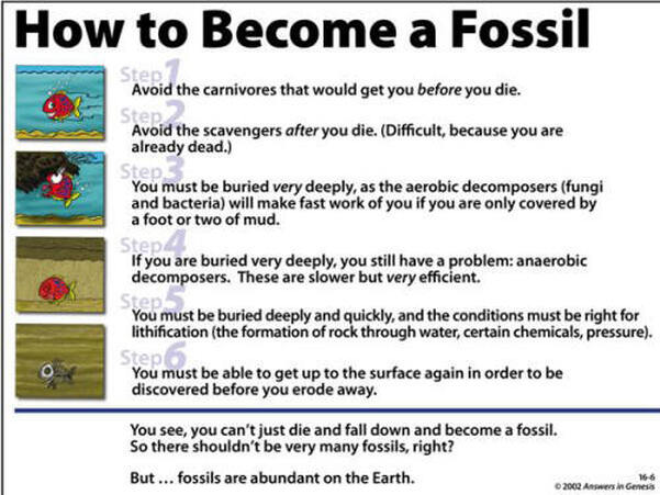
Now moving on to fossils in general, what actually leads to their formation in the first place and what do they tell us if there's a vast multitude of animals that die everyday across the world and they almost never fossilize?
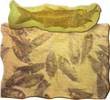
How long do you think it took this specifically to form if it was found in the Eocene varves of Fossil Lake in Wyoming and it's assumed that a foot of rock took two thousand years to form there?:
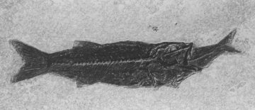
Are we supposed to believe these fish were not buried extremely quickly and deeply if they straight up had their meal still in their mouths?
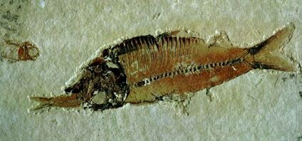
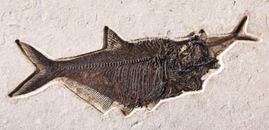
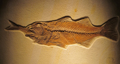
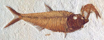

And the signs of activity that point to quick and deep burial are not limited to fish being in the process of eating a meal.
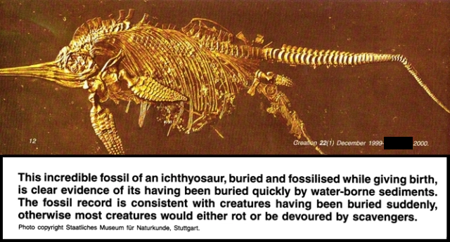
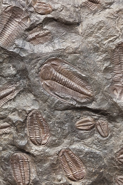
And consider mass mortality plates as well. Does this not point to a quick and deep burial under thick sediment if we have several creatures who all perished together?
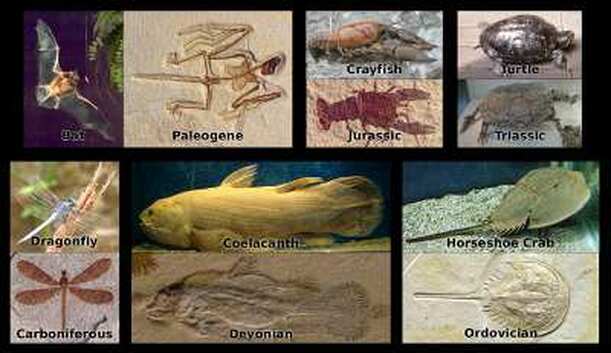
And what has changed over billions of year if we are told that life has been evolving here for that long? How telling if we can look at fossils that are allegedly from many epochs ago and yet they portray the same basic creatures that are in the world today?
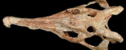
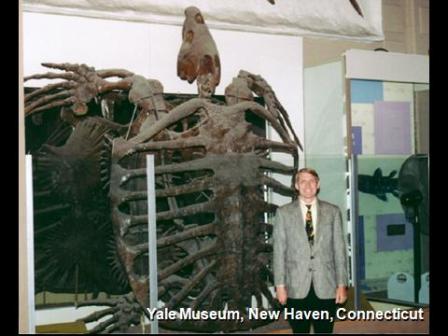
And would you believe that there have even been marine fossils found on top of huge mountains across the world like Mount Everest and the Andes Mountains? How about consider this and consider looking at mainstream scientific theory in an alternative light though. "Paleontologist Arturo Vildozola rests on a giant fossilized oyster...in Acostambo, Peru, where more than 500 fossilized giant oysters were found 2 miles above sea level. The discovery of the oysters, which are 11.5 feet wide and 661 pounds, reinforces the scientific theory that 200 million years ago the Andes Mountains were covered by the ocean."
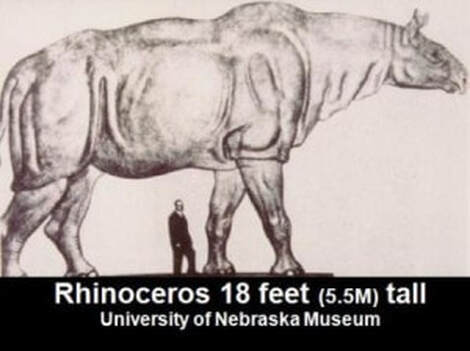
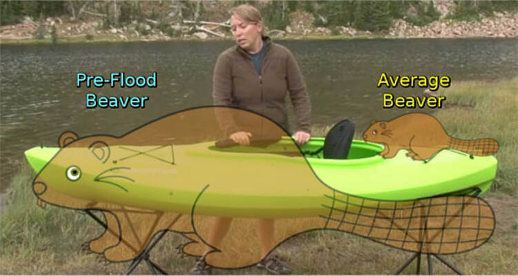
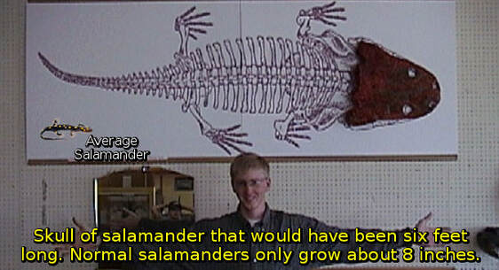
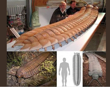
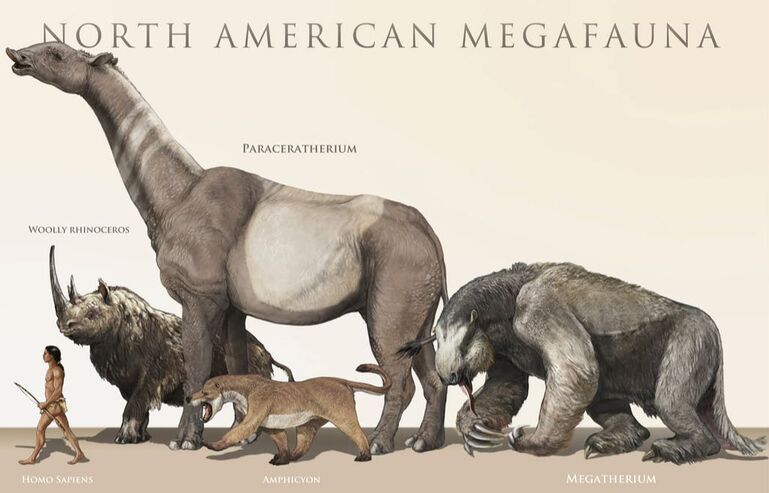
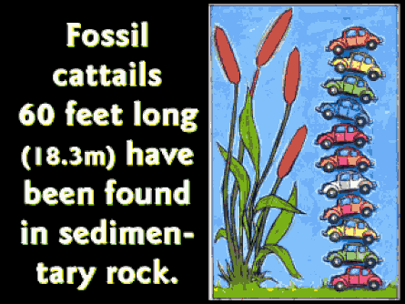
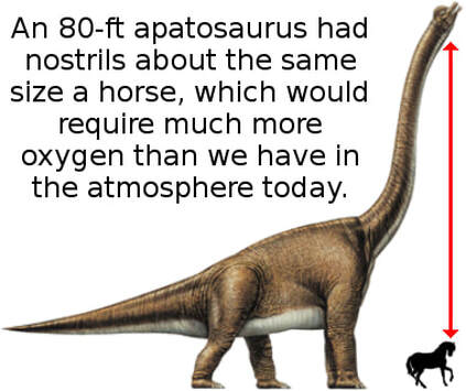
Talk of giant oysters helps to bring us into discussion regarding megafauna in general and megaflora as well. Ask yourself where giant fossils would really fit in if there was Not a world with much different atmospheric conditions in the past. "There are many more beyond this, from giant turkeys to giant sharks, but just based on these few discoveries, we can tell the pre-flood world was obviously very different than what we see today. So far, we've seen evidence of increased oxygen under pressure creating enhanced healing, easier breathing, larger animals, easier for birds to fly, enables large creatures to fly, and allows larger insects to exist. Although this is already amazing, we've only begun to scratch the surface of what is possible in hyperbaric conditions under a UV-blocking canopy..."


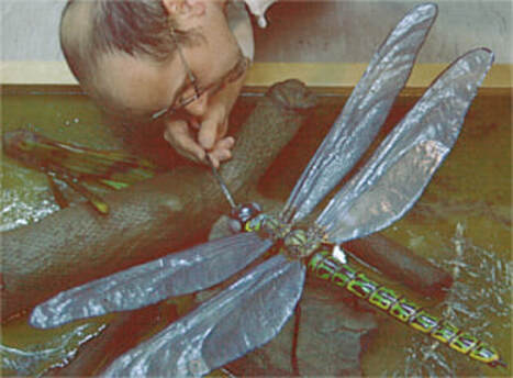

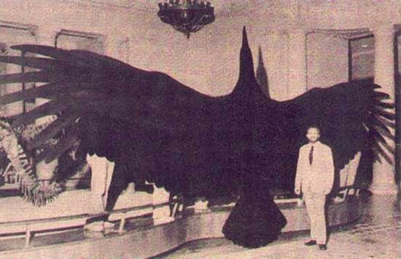


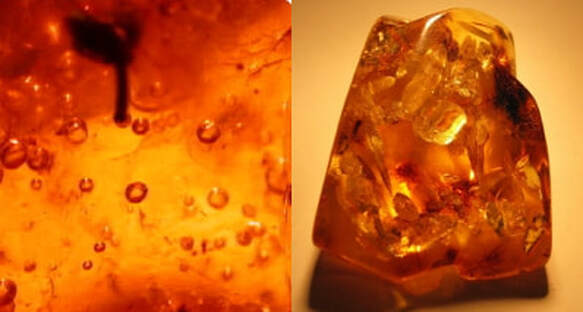
"It seems that there was more oxygen in the atmosphere before the Flood. "Even though [Jurassic Park] was fiction, what is fact is that pockets of air have been trapped in amber, and under scientific analysis, they have been found to contain 50% more oxygen than our atmosphere averages today." "...with an ice canopy around the planet, you can now create a hyperbaric oxygen condition, or in other words, oxygen under pressure. In the past couple of decades, a lot of experimentation has been done with healing people of numerous illness and injury, simply by putting them in pressurized oxygen conditions."
One of the most ridiculed portions of the Bible is the fifth chapter of Genesis, which gives vast ages for the lives of the patriarchs. Men once regularly lived to be over 900 years old! However, longevity dropped significantly after the Flood to a few hundred years, and finally came down to current averages by the time of the Exodus. What could cause such a dramatic drop-off in longevity since primeval times? Art Brown presents his theory of senescence (aging) in the book Methusaleh’s Secret, which reviews longevity statistics vis-à-vis geography, tells the story of people who live in steep canyons and valleys and attain great ages, and delves into the puzzling jump in longevity in the 1911-1951 timeframe. The gain in average lifespan during that timeframe when automation in transportation and production moved people indoors was greater even than the jump brought about by miracle drugs since. Brown concludes that exposure to the sun’s UV radiation is responsible for dramatically shortening our lives. His work climaxes with the sensational story of the Dickerson children. "These children lived secreted away in an attic until they were teenagers. [The first picture below] shows Connie, Gordon and Glenda Dickerson (18, 15, and 13 years of age respectively)."


These “Methusaleh Children” had nearly stopped aging! Although healthy and intelligent, they appeared to be many years younger than they actually were. Connie Dickerson was interviewed by Genesis Park in Canada. Though she was in her 60’s, she appeared to be a good decade younger. Art Brown theorizes that Methusaleh’s secret was the water canopy that surrounded the early earth and blocked harmful sunlight.

"Dr. Jack Cuozzo extensively studied Neanderthal bones and came to some startling conclusions. Based upon both cranial measurements...and tooth enamel wear, Cuozzo estimated the individuals at death were 250-300 years old! (Cuozzo, Jack, Buried Alive, 1999, pp. 203, 234.) Besides the early earth environment that [might] have contributed to such longevity, Cuozzo cites recent evidence from reconstructing ancient mammalian enzymes to show a dramatic decrease in efficiency over time. Such devolution could contribute in multiple ways to the wearing out of biological systems (p. 268). creationists would predict that life-forms in the fossil record would be larger, healthier and enjoy greater longevity than modern ones. This is because these biological systems will deteriorate over time." "And it's a simple fact the bones of your eyebrow ridge never stop growing. So if you could live to be 3 or 4 hundred years old, your eyebrow ridge would stick way out!"

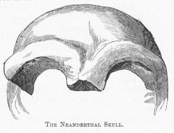
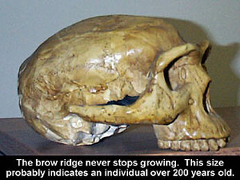
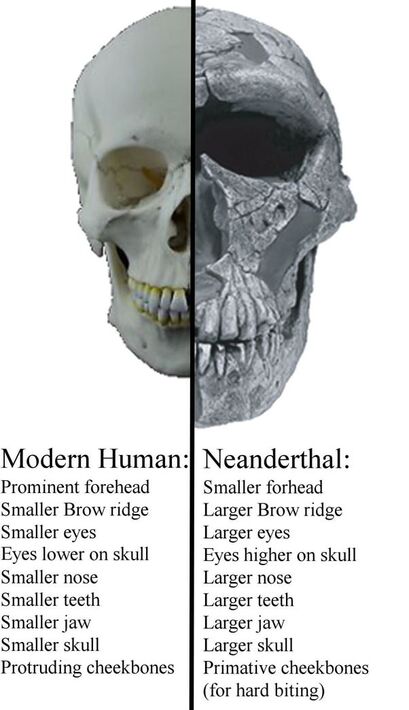
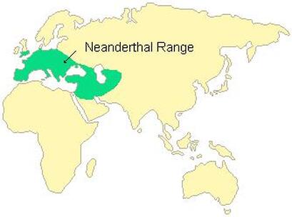
Consider where Neanderthal remains are found as well. Are these all early postflood humans if they all show signs of old age and they are all found relatively close to Mount Ararat?
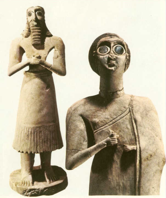
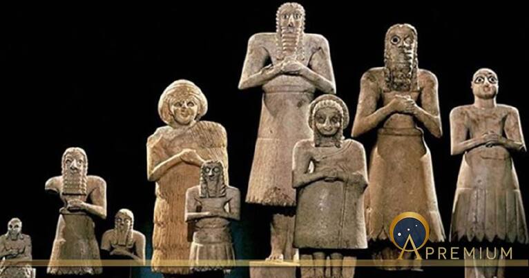
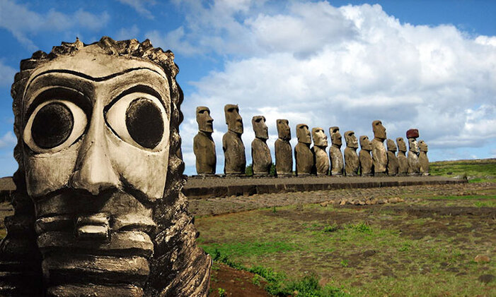
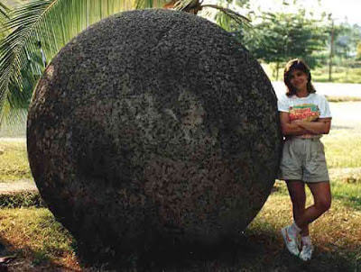
I suspect these famous island statues are preflood and an attempt to portray preflood people.
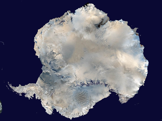
Also consider this and ask yourself what changed?: "It [might] be hard to believe, but Antarctica was once covered in towering forests." "Visiting the frozen wasteland of Antarctica today, it is hard to believe that rainforests haunted by small dinosaurs once flourished where 3km thick ice-sheets now exist."
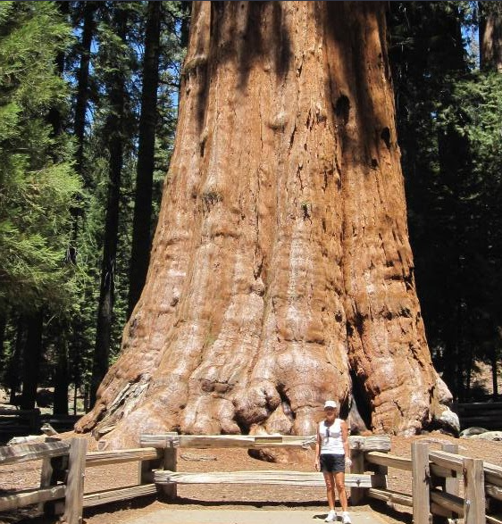
Now if the Flood is said to have occurred about 4,350 years ago, is there any evidence to help support that number in terms of ages for things that would have likely came to exist only after the Flood occurring?
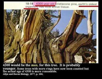
You might find an older number in more recent texts, but ring dating might be an extremely imperfect science and especially when you get into smaller trees. This being said, notice numbers right on Wikipedia itself if there are dozens and the highest dated using actual tree rings (as opposed to radiometric dating) has a number of 5,069 and that high comes with a disclaimer stating core is missing and date is unconfirmed? Why would we find several trees dated to about 4,000 and almost none that are older than that?
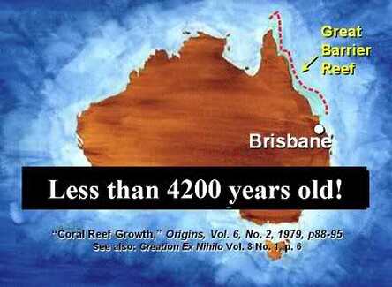
And consider the Great Barrier Reef as well. How interesting if the two oldest living biological organisms in the whole world date to about the time the Flood occurred according to Biblical dates?
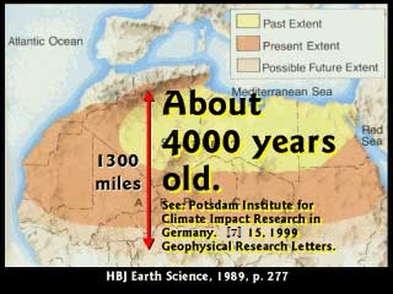
Consider how old the Sahara Desert is dated as well. And it's not limited to living organisms. "Did you know the Sahara Desert has what is called a prevailing wind pattern? The wind almost always blows the same direction. But that creates a problem because as the ground dries out and turns to desert, it keeps spreading. [The] Sahara Desert is growing. Now people living along the edge are speeding up the process, but even without people the desert would grow. Right now it is growing 4 to 5 miles a year. Well, [the] Sahara Desert is only 1300 miles north to south. It can only be a few thousand years old."
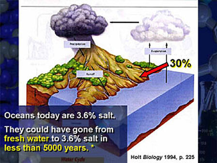
How interesting if the amount of salt in the oceans account for less than 5,000 years as well? "When it rains, 30% of the water runs into the ocean, bringing with it mineral salts. The oceans are getting saltier every day. Today they are 3.6% salt. They could have done that in less than 5,000 years."
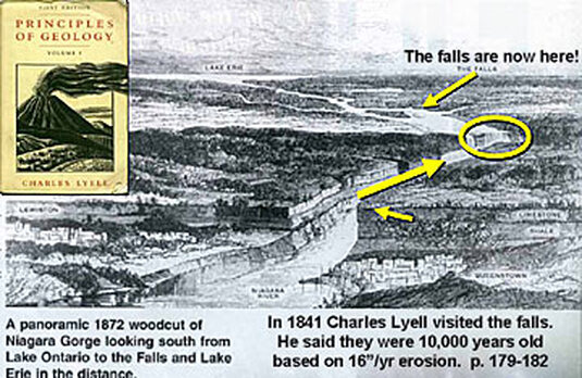
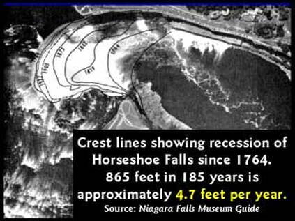
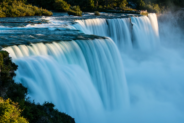
Also of note: "Niagara Falls’ erosion rate (four to five feet per year) indicates an age of less than 10,000 years. Don't forget Noah's Flood could have eroded half of the seven-mile-long Niagara River gorge in a few hours as the flood waters raced through the soft sediments.)"
Now let's step back and look at the world as a whole. Could there be some truth to what is said here?
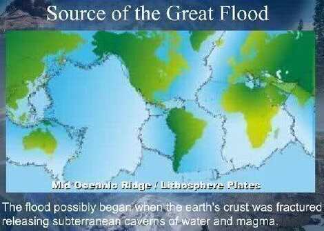
Well how interesting if we have a huge ocean with underwater cracks that are complete with stretch marks? Notice also if one of the cracks comes up towards the Gulf of California and the Western United States.
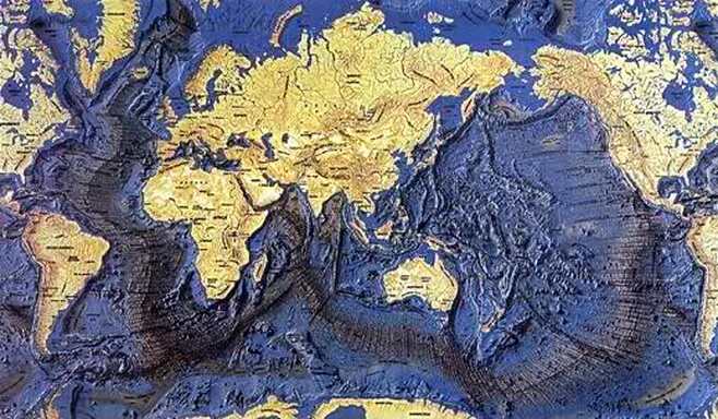
Now if we try to work back from what this images shows, can anyone rightly deny that some of these shapes seem to fit in with their neighbors like puzzle pieces across from the cracks or ridges? I bet you are already familiar with an image like this below.
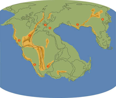
Wait though. How much sense would a lopsided island planet with Australia off to the side make if you consider how well Australia fits in with Africa and South America itself? How about look back to the underwater map and notice how well this fits in with that as well.
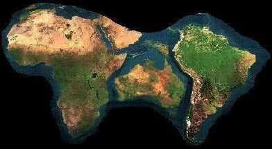
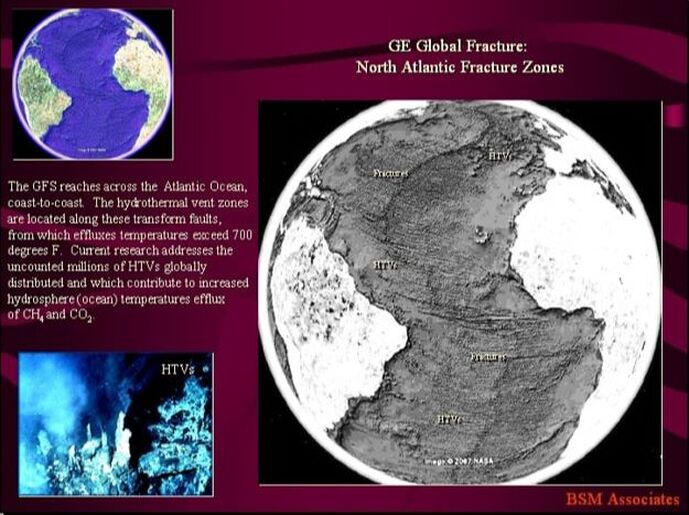
I propose that the world actually expanded during the Flood or at one or more point since Creation Week. Consider how well the fracture evidence and the puzzle piece evidence fits in with what we find below here.

One might argue that the world can't get larger without increased mass that comes from somewhere, but who knows what's inside exactly. There could be hollow spaces or something else that helps explain this. How interesting if there are extremely hot hydrothermal vents around these faults and scripture itself suggests that there are springs in the sea.
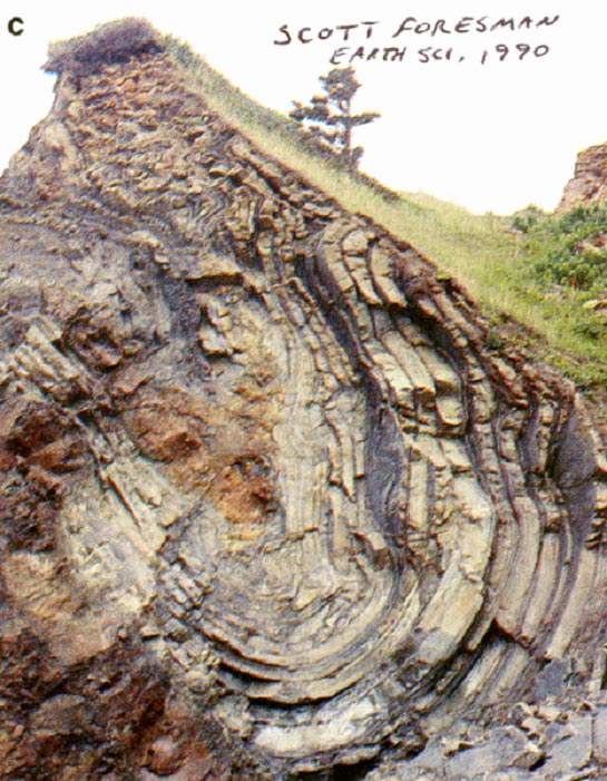
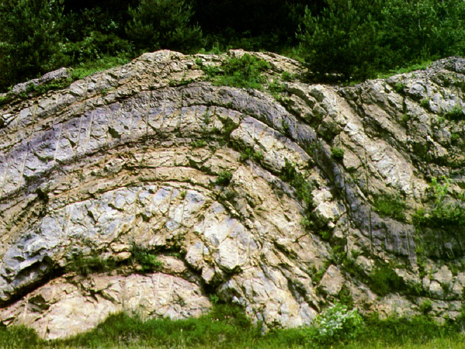
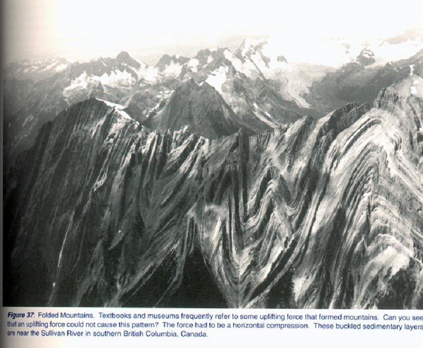
One might argue that the world could have never been flooded because there are mountains that are too high to have been reached with all the water in the world, but how many mountains existed before the Flood if there were obviously drastic geologic changes that occurred during it? How interesting if there are geologic features around the world (including gigantic mountains) that look like they are essentially the result of layers of muddy sediment buckling while in a putty-like state?


"Paradoxically, the first pyramids to have been built, those of the 3rd and 4th dynasty (Old Kingdom Pyramids), have stood the test of time better than those built in the 12th dynasty (Middle Kingdom Pyramids). This is because the Old Kingdom Pyramids were made entirely out of solid limestone blocks while the Middle Kingdom Pyramids were made largely from Mud Bricks (the core) and only had a veneer of limestone."
Note: All verses from the Restored Name King James Version unless otherwise noted. I might be a simple man and be saying some stuff that is wrong. I expect to be surprised by one thing or another and welcome input with hope that I will be corrected where I'm in error. Both myself and this website are a work in process.
